Local Government
Shark Bay
Region
Gascoyne
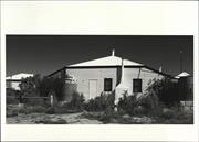
Lot 3090 Useless Loop Rd Carrarang
Carrarang Peninsula
Shark Bay
Gascoyne
Constructed from 1920
| Type | Status | Date | Documents |
|---|---|---|---|
| (no listings) |
| Type | Status | Date | Documents |
|---|---|---|---|
| (no listings) |
| Type | Status | Date | Grading/Management | |
|---|---|---|---|---|
| Category | ||||
| Municipal Inventory | Adopted | 12 Dec 1997 | Category 2 | |
12412 Shark Bay Area
| Library Id | Title | Medium | Year Of Publication |
|---|---|---|---|
| 1946 | Survey of the built environment at Shark Bay. | Report | 1988 |
Individual Building or Group
| Epoch | General | Specific |
|---|---|---|
| Present Use | FARMING\PASTORAL | Homestead |
| Original Use | FARMING\PASTORAL | Homestead |
| Type | General | Specific |
|---|---|---|
| Roof | METAL | Corrugated Iron |
| Wall | STONE | Limestone |
| General | Specific |
|---|---|
| DEMOGRAPHIC SETTLEMENT & MOBILITY | Settlements |
This information is provided voluntarily as a public service. The information provided is made available in good faith and is derived from sources believed to be reliable and accurate. However, the information is provided solely on the basis that readers will be responsible for making their own assessment of the matters discussed herein and are advised to verify all relevant representations, statements and information.
Constructed from 1920
The Carrarang Homestead, although not the original, has historic significance for its connection with the development of Shark Bay and the pastoral industry. The use of local materials (limestone) adds significance to the place.
This house is constructed mostly of random rubble limestone with a small section to the front being timber framed with fibro cladding. The building has a corrugated iron gambrel roof with a lean to roof to the north which extends to cover the front verandah. The main roof also has broken back extensions which cover verandahs to the west and south which have a timber balustrade. The verandahs are supported on timber posts and are partly enclosed with corrugated iron to the south and lattice to the north. A bay window has been added to the west. Windows are mostly timber framed and double hung with the bay to the west having small paned casement windows. The two timber doors to the front verandah have six window panes. A small rendered chimney is located to the north at the base of the main roof. Internally there are tongue and groove timber ceilings.
This is the second homestead built on Carrarang Station. The original was timber framed and is believed to have been replaced in the 1920s. The bay window was added in the 1970's by Graeme Rowlands. In the mid 1960's a cyclone demolished the old shearing shed and men's quarters, there being no trace of either remaining. The first leaseholder of the Carrarang area was Maitland Brown in 1873. The lease was transferred to August von Bibra in 1879. In 1888 the syndicate of W.D. Moore & Co. took over the leasehold. After World War I the property was part of J. H. Spaven's pastoral leases and remained under his control for over 50 years. Graeme Rowlands was the manager of the property for the leaseholder, Agnew Clough Limited from about 1970 until 1978. (Source: Max Hipkins & Associates, "Survey of the Built Environment of Shark Bay", Department of Planning and Urban Development, 1991, pp7-8.)
Integrity: High Degree
Good
| Ref ID No | Ref Name | Ref Source | Ref Date |
|---|---|---|---|
| M Hipkins; "Survey of the Built Environment of Shark Bay". p.7-8 | DPUD | 1991 |
This information is provided voluntarily as a public service. The information provided is made available in good faith and is derived from sources believed to be reliable and accurate. However, the information is provided solely on the basis that readers will be responsible for making their own assessment of the matters discussed herein and are advised to verify all relevant representations, statements and information.
Dampier Rd Denham
Shark Bay
Gascoyne
Constructed from 1987
| Type | Status | Date | Documents |
|---|---|---|---|
| (no listings) |
| Type | Status | Date | Documents |
|---|---|---|---|
| (no listings) |
| Type | Status | Date | Grading/Management | |
|---|---|---|---|---|
| Category | ||||
| Fire & Rescue Service Heritage Inventory | Adopted | 30 Aug 1997 | ||
Individual Building or Group
| Epoch | General | Specific |
|---|---|---|
| Original Use | GOVERNMENTAL | Fire Station |
| Present Use | GOVERNMENTAL | Fire Station |
| Type | General | Specific |
|---|---|---|
| Roof | METAL | Other Metal |
| Wall | ASBESTOS | Fibrous Cement, flat |
| General | Specific |
|---|---|
| SOCIAL & CIVIC ACTIVITIES | Community services & utilities |
This information is provided voluntarily as a public service. The information provided is made available in good faith and is derived from sources believed to be reliable and accurate. However, the information is provided solely on the basis that readers will be responsible for making their own assessment of the matters discussed herein and are advised to verify all relevant representations, statements and information.
6 Denham Hamelin Rd Denham
Shark Bay Secondary Education Group
Shark Bay
Gascoyne
Constructed from 1910 to 1930
| Type | Status | Date | Documents |
|---|---|---|---|
| (no listings) |
| Type | Status | Date | Documents |
|---|---|---|---|
| (no listings) |
| Type | Status | Date | Grading/Management | |
|---|---|---|---|---|
| Category | ||||
| Municipal Inventory | Adopted | 11 Mar 1997 | Category 2 | |
02369 Denham Townsite Buildings
Fair Changed construction date MI states that building was completed in 1910 for use as a post office and then changed use in 1930 for use as police Lock Up. BDD 28/03/12
Individual Building or Group
| Epoch | General | Specific |
|---|---|---|
| Original Use | GOVERNMENTAL | Police Station or Quarters |
| Present Use | VACANT\UNUSED | Vacant\Unused |
| Style |
|---|
| Vernacular |
| Type | General | Specific |
|---|---|---|
| Roof | METAL | Corrugated Iron |
| Wall | TIMBER | Weatherboard |
| General | Specific |
|---|---|
| SOCIAL & CIVIC ACTIVITIES | Law & order |
| DEMOGRAPHIC SETTLEMENT & MOBILITY | Settlements |
This information is provided voluntarily as a public service. The information provided is made available in good faith and is derived from sources believed to be reliable and accurate. However, the information is provided solely on the basis that readers will be responsible for making their own assessment of the matters discussed herein and are advised to verify all relevant representations, statements and information.
Constructed from 1910, Constructed from 1930
The former Police Station, Lock-up and Stables has historic significance for its connection with the development of the area, in particular with regard to law and order. If verified that the building was also used as a Post Office, the place has further significance for its association with communications in the isolated district. Together the three buildings form a unique little precinct with the significance of each separate building enhancing the others. The main building is representative of the built environment of the town, being simple in style, basic in material with surrounding verandahs to combat the heat.
MAIN BUILDING: Located on the main entry street into Denham, this large 'L' shaped timber framed building is clad with fibro. The building has a hipped asbestos roof which extends to cover the surrounding verandahs. The verandahs are supported on timber posts. Fibro infill has been used between the posts below the balustrade. Entrance to the front verandah is via timber steps with a metal railing. Windows are timber framed and casement style. LOCK-UP: Located to the rear of the main building, the Lock-up is a small rectangular timber frame building clad with weatherboards with a corrugated iron gable roof. The roof extends to form eaves along each side of the building. The gable ends have timber ventilation slots. There are two large cylindrical air vents to the roof. There are two entry doors to the north side of the building which have barred openings above. To the sides of each door at floor level there is a hinged timber flap. Several weatherboards are missing to the east elevation. STABLES: To the rear of the lot is a small rectangular timber framed building with a corrugated iron gable roof. The place is clad with both vertical and horizontal corrugated iron, with a large access door to the north elevation.
Police presence was established in Shark Bay on 1 February, 1874. The original Police Station was located in a rented house at Useless Loop. Police duties included patrolling the Gascoyne and Freshwater Camp (Denham), inspecting pearling grounds and visiting stations. Additional duties often included distributing mail in the Police cutter to Dirk Hartog and Friday Islands, collecting agricultural and stock statistics, conducting censuses, collecting customs duty, lighting beacon lights and supplying rations to aborigines. In 1885 the police officers at Shark Bay petitioned for a permanent station to be located at Freshwater Camp and in 1887 construction of a police station was completed, located on the corner of Hamelin Road and Knight Terrace. It is believed that the second Police Station building was originally constructed to house a post office (c.1910) but was used as a police station from the mid 1930s. In 1987 the Police considered expanding the building however abandoned the plans in favour of a new building which was constructed in 1991. The building has since been used by a Distance Education Group. (Source: Max Hipkins & Associates, "Survey of the Built Environment of Shark Bay", Department of Planning and Urban Development, 1991, p19-21.)
Integrity: High Degree
Good
| Ref ID No | Ref Name | Ref Source | Ref Date |
|---|---|---|---|
| M Hipkins; "Survey of the Built Environment of Shark Bay". | DPUD | 1991 |
| Owner | Category |
|---|---|
| Education Department | State Gov't |
This information is provided voluntarily as a public service. The information provided is made available in good faith and is derived from sources believed to be reliable and accurate. However, the information is provided solely on the basis that readers will be responsible for making their own assessment of the matters discussed herein and are advised to verify all relevant representations, statements and information.
10 Denham Rd Denham
Police Station, Lock-up & Stables
Shark Bay Secondary Education Group Building
Shark Bay
Gascoyne
Constructed from 1884
| Type | Status | Date | Documents |
|---|---|---|---|
| (no listings) |
| Type | Status | Date | Documents |
|---|---|---|---|
| (no listings) |
| Type | Status | Date | Grading/Management | |
|---|---|---|---|---|
| Category | ||||
| (no listings) | ||||
Individual Building or Group
| Epoch | General | Specific |
|---|---|---|
| Original Use | GOVERNMENTAL | Police Station or Quarters |
| Present Use | EDUCATIONAL | Secondary School |
| Type | General | Specific |
|---|---|---|
| Wall | ASBESTOS | Fibrous Cement, weatherboard |
| Roof | ASBESTOS | Fibrous Cement, corrugated |
| General | Specific |
|---|---|
| SOCIAL & CIVIC ACTIVITIES | Law & order |
| SOCIAL & CIVIC ACTIVITIES | Education & science |
This information is provided voluntarily as a public service. The information provided is made available in good faith and is derived from sources believed to be reliable and accurate. However, the information is provided solely on the basis that readers will be responsible for making their own assessment of the matters discussed herein and are advised to verify all relevant representations, statements and information.
Dirk Hartog Island, Shark Bay Denham
About 70,000 hectares, loc 40 km W of Denham, on the W side Denham Sound & Shark Bay. Also part of P12412 Shark Bay Area
Shark Bay
Gascoyne
| Type | Status | Date | Documents |
|---|---|---|---|
| National Heritage List | YES | 07 Apr 2006 |
| Type | Status | Date | Documents |
|---|---|---|---|
| (no listings) |
| Type | Status | Date | Grading/Management | |
|---|---|---|---|---|
| Category | ||||
| Municipal Inventory | Adopted | 12 Dec 1997 | Category 2 | |
| Register of the National Estate | Adopted | 21 Mar 1978 | ||
07402 Dirk Hartog Island
Individual Building or Group
| Epoch | General | Specific |
|---|---|---|
| Original Use | FARMING\PASTORAL | Servants or Shearers Quarters |
| Present Use | FARMING\PASTORAL | Homestead |
| Type | General | Specific |
|---|---|---|
| Roof | METAL | Corrugated Iron |
| Wall | STONE | Other Stone |
| General | Specific |
|---|---|
| DEMOGRAPHIC SETTLEMENT & MOBILITY | Settlements |
| OCCUPATIONS | Grazing, pastoralism & dairying |
This information is provided voluntarily as a public service. The information provided is made available in good faith and is derived from sources believed to be reliable and accurate. However, the information is provided solely on the basis that readers will be responsible for making their own assessment of the matters discussed herein and are advised to verify all relevant representations, statements and information.
The Dirk Hartog Station buildings have historic significance for their connection with the development of the pastoral industry in Shark Bay. As a group, this collection of stone and corrugated iron clad buildings and structures reflect the workings and way of life of pastoral stations in the district.
The Consultants were unable to visit this place and therefore the description below is compiled from photographic evidence. HOMESTEAD: The original homestead has been burned down and the large shearers' quarters has been converted for use as a homestead. The stone building appears to have a corrugated iron skillion roof with a separate verandah roof which is supported on timber posts. An area to the side of the building is fenced and has a timber picket gate. SHEARING SHED: This is a large timber framed corrugated iron building with a gable roof and long broken back extensions to each side. A tall rectangular corrugated iron clad tower with external timber framing and a hipped roof of flat metal, protrudes from the centre of the building, built to accommodate the wool press. The front facade has an enclosed lean-to with double timber doors. The side has a tall covered accessway. The corrugated iron cladding is used vertically and the whole building has been painted leaf green. SADDLE ROOM: Beyond the shearing shed is a small timber framed corrugated iron clad building which has a low pitched corrugated iron skillion roof. To the front facade there is a tall open doorway and beside it is a timber entry door and two windows. In front of the door and windows there is a pergola with a shade cloth roof and side. The building has vertically placed corrugated iron cladding and is painted leaf green. WORKSHOP AND MILL ROOM: Sited between the homestead and the shearing shed, the workshop is a tall timber framed building with a gable roof. To the front of the workshop a small rectangular timber framed corrugated iron clad building with a low pitched skillion roof is referred to as the "mill room". Both structures are clad with vertically placed corrugated iron and are painted leaf green. STOREHOUSE AND POWER STATION: This small timber framed corrugated iron building has had a lean-to added to one side. The use of corrugated iron and paint colour matches the other outbuildings. The building is close to the site of the homestead and the remnants of palm trees and rain water tank bases are evidence of this. WEST WELL: Sited in an open area of limestone, the well is surrounded by a steel fence with two windmills and a water tank nearby. Water is pumped from this site to other points on the property.
Dirk Hartog Island was so named for the explorer who left an inscribed plate nailed to a timber post on the west side of the island in 1616. This area, later called Cape Inscription, was visited in 1697 by Willem de Vlamingh who subsequently removed Hartog's Plate and replaced it with one of his own. Close to this site is the Cape Inscription Lighthouse and Quarters. The pastoral industry began on Dirk Hartog Island in 1873 when Frank L. von Bibra leased the island along with other holdings.
Integrity: Medium Degree
Good
This information is provided voluntarily as a public service. The information provided is made available in good faith and is derived from sources believed to be reliable and accurate. However, the information is provided solely on the basis that readers will be responsible for making their own assessment of the matters discussed herein and are advised to verify all relevant representations, statements and information.
9 Francis Rd Denham
Shark Bay
Gascoyne
Constructed from 1904
| Type | Status | Date | Documents |
|---|---|---|---|
| (no listings) |
| Type | Status | Date | Documents |
|---|---|---|---|
| (no listings) |
| Type | Status | Date | Grading/Management | |
|---|---|---|---|---|
| Category | ||||
| Municipal Inventory | Adopted | 12 Dec 1997 | Category 2 | |
| Register of the National Estate | Registered | 21 Mar 1978 | ||
02369 Denham Townsite Buildings
Fair
Individual Building or Group
| Epoch | General | Specific |
|---|---|---|
| Present Use | VACANT\UNUSED | Vacant\Unused |
| Original Use | GOVERNMENTAL | Office or Administration Bldg |
| Style |
|---|
| Vernacular |
| Type | General | Specific |
|---|---|---|
| Wall | METAL | Corrugated Iron |
| Roof | METAL | Corrugated Iron |
| General | Specific |
|---|---|
| SOCIAL & CIVIC ACTIVITIES | Government & politics |
This information is provided voluntarily as a public service. The information provided is made available in good faith and is derived from sources believed to be reliable and accurate. However, the information is provided solely on the basis that readers will be responsible for making their own assessment of the matters discussed herein and are advised to verify all relevant representations, statements and information.
Constructed from 1904
The Former Shark Bay Road Office has considerable historic significance for its link with local government in the district. Further it is one of the oldest remaining buildings in Denham. The building is typical of the primitive offices constructed of basic materials used by local government in remote areas around the turn of the century, given its small scale, basic materials and simple style.
Located in the DSA Grounds, the Former Shark Bay Roads Board Office is a small one-roomed timber framed building which is clad with corrugated iron. The simple structure has a corrugated iron gable roof which extends to form eaves at the rear and a small verandah to the front elevation. Corrugated iron sheeting has been used to partly enclose the verandah. The building, which is timber lined with timber floors, has small timber framed six pane windows to each side elevation. There is an entry door to the front and rear. Set on concrete footings, the building is secured with steel cable.
The building was constructed at Denham for the Shark Bay Road Board in 1904. When the new Shark Bay Shire Office was opened in 1968 the old building was moved to Wolgedda where it was used as a museum. The Fmr Road Board Office has since been relocated back to Denham. (Source: "Trust Newsletter", April, 1975; Max Hipkins & Associates, "Survey of the Built Environment of Shark Bay", Department of Planning and Urban Development", 1991, pp33-34.)
Integrity: High Degree
Fair
| Ref ID No | Ref Name | Ref Source | Ref Date |
|---|---|---|---|
| M Hipkins; "Survey of the Built Environment of Shark Bay". p33-34 | DPUD | 1991 | |
| "Trust Newsletter". | April, 1975 |
| Owner | Category |
|---|---|
| Shire of Shark Bay | Local Gov't |
This information is provided voluntarily as a public service. The information provided is made available in good faith and is derived from sources believed to be reliable and accurate. However, the information is provided solely on the basis that readers will be responsible for making their own assessment of the matters discussed herein and are advised to verify all relevant representations, statements and information.
29 Hughes St Denham
Hospital
Shark Bay
Gascoyne
Constructed from 1935
| Type | Status | Date | Documents |
|---|---|---|---|
| (no listings) |
| Type | Status | Date | Documents |
|---|---|---|---|
| (no listings) |
| Type | Status | Date | Grading/Management | |
|---|---|---|---|---|
| Category | ||||
| Municipal Inventory | Adopted | 12 Dec 1997 | Category 2 | |
| Library Id | Title | Medium | Year Of Publication |
|---|---|---|---|
| 1946 | Survey of the built environment at Shark Bay. | Report | 1988 |
Individual Building or Group
| Epoch | General | Specific |
|---|---|---|
| Original Use | HEALTH | Hospital |
| Present Use | SOCIAL\RECREATIONAL | Other Community Hall\Centre |
| Type | General | Specific |
|---|---|---|
| Roof | METAL | Corrugated Iron |
| Wall | ASBESTOS | Fibrous Cement, weatherboard |
| General | Specific |
|---|---|
| SOCIAL & CIVIC ACTIVITIES | Community services & utilities |
This information is provided voluntarily as a public service. The information provided is made available in good faith and is derived from sources believed to be reliable and accurate. However, the information is provided solely on the basis that readers will be responsible for making their own assessment of the matters discussed herein and are advised to verify all relevant representations, statements and information.
Constructed from 1935
The Old Hospital has historic significance for its connection with the medical services in Shark Bay. Further the building has social significance given the valuable contribution it currently makes as a meeting place for a number of community groups. The building also adds to the character of the town, being largely of weatherboard construction with surrounding verandahs and located in a prominent position on Hughes Street.
The Old Hospital is a medium sized building with a twin gable corrugated iron roof and hipped surrounding verandahs. There are timber slatted air vents to the gable ends. The building is set on timber stumps with timber flooring to the verandahs. The verandahs are supported on timber posts. Access to the front verandah is via a ramp with a metal hand rail. The original (front) section of the building has weatherboard cladding with timber framed double hung windows. The verandahs are partially enclosed with fibro below and timber framed casement windows above.
The original (front) section of the building was constructed in the mid 1930s by shipwright and carpenter, Tas Fletcher, who was also responsible for building Ma Fletcher's house. (Place No. 12). The later addition also has a gable roof, complimenting the original. In May, 1988 a portion of the front verandah was demolished by Cyclone Herbie, but has been repaired. At present, several community groups use the building as a meeting venue. (Source: Max Hipkins & Associates, "Survey of the Built Environment of Shark Bay", Department of Planning and Urban Development, 1991, p23.)
Integrity: High Degree
Good
| Ref ID No | Ref Name | Ref Source | Ref Date |
|---|---|---|---|
| M Hipkins; "Survey of the Built Environment of Shark Bay". p.23 | DPUD | 1991 |
This information is provided voluntarily as a public service. The information provided is made available in good faith and is derived from sources believed to be reliable and accurate. However, the information is provided solely on the basis that readers will be responsible for making their own assessment of the matters discussed herein and are advised to verify all relevant representations, statements and information.
35 Hughes St Denham
Cnr Hughes & Brockman Sts
Shark Bay
Gascoyne
Constructed from 1954
| Type | Status | Date | Documents |
|---|---|---|---|
| (no listings) |
| Type | Status | Date | Documents |
|---|---|---|---|
| (no listings) |
| Type | Status | Date | Grading/Management | |
|---|---|---|---|---|
| Category | ||||
| Municipal Inventory | Adopted | 12 Dec 1997 | Category 2 | |
| Library Id | Title | Medium | Year Of Publication |
|---|---|---|---|
| 1946 | Survey of the built environment at Shark Bay. | Report | 1988 |
Individual Building or Group
| Epoch | General | Specific |
|---|---|---|
| Original Use | RELIGIOUS | Church, Cathedral or Chapel |
| Present Use | RELIGIOUS | Church, Cathedral or Chapel |
| Type | General | Specific |
|---|---|---|
| Wall | BRICK | Other Brick |
| Roof | ASBESTOS | Fibrous Cement, corrugated |
| General | Specific |
|---|---|
| SOCIAL & CIVIC ACTIVITIES | Religion |
This information is provided voluntarily as a public service. The information provided is made available in good faith and is derived from sources believed to be reliable and accurate. However, the information is provided solely on the basis that readers will be responsible for making their own assessment of the matters discussed herein and are advised to verify all relevant representations, statements and information.
Constructed from 1954
St. Andrew's Anglican Church has social significance for its role in the religious activities of the local community. Further the use of coquina shell block and its prominent position on Hughes Street make the place important to the character of the town.
St. Andrew's Church is a small rectangular building of coquina shell block construction, with a small extension to the east. The building has an asbestos gable roof with a shallow pitch. There are two timber crosses at each end of the building to the top of the gable. The roof, which is supported on steel trusses with internal steel uprights, extends to form an eaves overhang about one metre beyond the walls with supporting metal posts. The windows are small, gothic arched with leadlights. Bottles are also incorporated into the walls as an additional feature. The building has a concrete floor with brick pavers. The entry door is surrounded by fibro sheeting and there is a bell hanging under the eaves at the south west corner. The building has a low metal rail pole fence to the west.
Prior to the construction of the church, services were held in the Shire Hall. Funding for this church was provided from the 'League of Help", a group based in England dedicated to erecting churches overseas, following the bombing of St. Andrew's-by-the Wardrobe Church in London during World War II. A simple design was drawn up by Perth architects Hawkins and Sands and construction commenced on 24 February, 1954. The shell blocks were quarried from the beach at Hamelin, (Place No. 21), many of them being sawn by the then Rector of Carnarvon, the Rev. Ron Hobby. The supervision of the construction was carried out by Mr. R.J. Davies of Perth, with two Italian stone masons and an Estonian carpenter. The building was opened and consecrated on 6 June, 1954 by Bishop Frewer. The stained glass window depicting the cross of St. Andrew and the pews came from St. Andrew's Church, Subiaco. During the late 1950s services were conducted once every six weeks when a minister visited Denham. The vestry extension was built in 1966, and this was dedicated by Bishop Howell Witt on 31 July, 1966. In 1968 Shark Bay became one of the many centres of the new Gascoyne-Ashburton parish, having previously been under the care of the Carnarvon parish. The church has also been used by other Christian denominations - it being the only church in the Shark Bay area. (Sources: Church pamphlet; Max Hipkins & Associates, "Survey of the Built Environment of Shark Bay", Department of Planning and Urban Development, 1991, pp21-22.)
Integrity: High Degree
Good
| Name | Type | Year From | Year To |
|---|---|---|---|
| Hawkins & Sands | Architect | 1954 | - |
| Ref ID No | Ref Name | Ref Source | Ref Date |
|---|---|---|---|
| M Hipkins; "Survey of the Built Environment of Shark Bay". p.21-22 | DPUD | 1991 | |
| Church Pamphlet |
| Owner | Category |
|---|---|
| NW Diocese Anglican Church | Church Property |
This information is provided voluntarily as a public service. The information provided is made available in good faith and is derived from sources believed to be reliable and accurate. However, the information is provided solely on the basis that readers will be responsible for making their own assessment of the matters discussed herein and are advised to verify all relevant representations, statements and information.
39 Hughes St Denham
Cnr Hughes & Brockman Sts
Shark Bay
Gascoyne
Constructed from 1961, Constructed from 1955
| Type | Status | Date | Documents |
|---|---|---|---|
| (no listings) |
| Type | Status | Date | Documents |
|---|---|---|---|
| RHP - Does not warrant assessment | Current | 25 Jan 2006 |
| Type | Status | Date | Grading/Management | |
|---|---|---|---|---|
| Category | ||||
| Municipal Inventory | Adopted | 12 Dec 1997 | Category 3 | |
| Library Id | Title | Medium | Year Of Publication |
|---|---|---|---|
| 1946 | Survey of the built environment at Shark Bay. | Report | 1988 |
Individual Building or Group
| Epoch | General | Specific |
|---|---|---|
| Original Use | EDUCATIONAL | Primary School |
| Present Use | EDUCATIONAL | Combined School |
| Type | General | Specific |
|---|---|---|
| Roof | ASBESTOS | Fibrous Cement, corrugated |
| Wall | ASBESTOS | Fibrous Cement, weatherboard |
| General | Specific |
|---|---|
| SOCIAL & CIVIC ACTIVITIES | Education & science |
This information is provided voluntarily as a public service. The information provided is made available in good faith and is derived from sources believed to be reliable and accurate. However, the information is provided solely on the basis that readers will be responsible for making their own assessment of the matters discussed herein and are advised to verify all relevant representations, statements and information.
Constructed from 1955
The Shark Bay Primary School has social significance for its role in education in the district. Further, the place has aesthetic significance given its commanding position and large size; it being one of the largest buildings of its era in Denham. Both of these elements combine to give the place high townscape value. In addition, its simple design for the climate, with surrounding verandahs, is representative of the building types in the town.
Located in a prominent position overlooking the bay, this large timber framed building is clad with fibro. The hipped asbestos roof extends to cover surrounding verandahs which are supported on timber posts. The verandah is open at the front with a timber balustrade and enclosed at the sides and rear with fibro. There are two sets of timber entry steps with timber rails to the front verandah. Windows are timber framed and awning style to the verandah infill, with 12 pane double hung windows to the central part of the building. To the rear of the main building is a separate timber framed fibro clad toilet block with a gable roof. To the west of the school is the living quarters - a fibro clad cottage with a partially enclosed verandah.
The first school opened in Denham on 10 May, 1897. Mr. J. Knight was the Chairman of the School Board. The first school building was in use until 1955 when the present school and quarters were completed. The original school was subsequently demolished. (Source: Max Hipkins & Associates, "Survey of the Built Environment of Shark Bay", Department of Planning and Urban Development, 1991, p21.)
Integrity: High Degree
Good
| Ref ID No | Ref Name | Ref Source | Ref Date |
|---|---|---|---|
| M Hipkins; "Survey of the Built Environment of Shark Bay". p.21 | DPUD | 1991 |
| Owner | Category |
|---|---|
| Education Department | State Gov't |
This information is provided voluntarily as a public service. The information provided is made available in good faith and is derived from sources believed to be reliable and accurate. However, the information is provided solely on the basis that readers will be responsible for making their own assessment of the matters discussed herein and are advised to verify all relevant representations, statements and information.
86 Hughes St Denham
in MI as 42 Hughes St
Shark Bay
Gascoyne
Constructed from 1985, Constructed from 1980
| Type | Status | Date | Documents |
|---|---|---|---|
| (no listings) |
| Type | Status | Date | Documents |
|---|---|---|---|
| (no listings) |
| Type | Status | Date | Grading/Management | |
|---|---|---|---|---|
| Category | ||||
| Statewide War Memorial Survey | Completed | 01 May 1996 | ||
| Municipal Inventory | Adopted | 12 Dec 1997 | Category 2 | |
Other Built Type
| Epoch | General | Specific |
|---|---|---|
| Present Use | PARK\RESERVE | Park\Reserve |
| Original Use | MONUMENT\CEMETERY | Monument |
| Type | General | Specific |
|---|---|---|
| Other | BRICK | Common Brick |
| Other | STONE | Marble |
| Other | METAL | Other Metal |
| General | Specific |
|---|---|
| PEOPLE | Famous & infamous people |
| OUTSIDE INFLUENCES | World Wars & other wars |
This information is provided voluntarily as a public service. The information provided is made available in good faith and is derived from sources believed to be reliable and accurate. However, the information is provided solely on the basis that readers will be responsible for making their own assessment of the matters discussed herein and are advised to verify all relevant representations, statements and information.
Constructed from 1980, Constructed from 1985
Pioneer Park has considerable historic significance containing as it does several important items which relate to the historical development of he district. Further, the place is held in high esteem by the local community.
Pioneer Park is prominently located on Hughes Street overlooking the Bay. The park contains a War Memorial, a plaque mounted on a carved rock, a headstone, a pearl lugger and a large camel wagon. PLAQUE: The metal plaque is mounted on a piece of rock which was taken from a cliff face at Eagle Bluff and is believed to have been inscribed witht he year 1858 by Captain Denham. Situated on a concrete base, it is surrounded by eight small shell block plinths joined by a metal chain. HEADSTONE: The single gothic arched marble headstone reads: "Lewis Clarkson Durlacher, Accidentally shot himself at Shark Bay, 13th Feb 1889, aged 23 years". PEARL LUGGER: The boat is located tot he South-West corner of the park and sits on blocks. A raised timber viewing platform has been constructed on the south side of the boat.
A plaque located at the entrance to the park reveals that Pioneer park reveals that Pioneer Park was opeend on the 28th May 1980 by the Deputy Shire President Cr PM Collier. The plaque reads: "Dedicated to the pioneers of Shark Bay. This park was the original grave yard for the area. The only remaining grave is that of Lewis Clarkson Durlacher". The carved rock in Pioneer Park is believed to have been inscribed by Captain Denham, who charted the Bay and after whom the town is named. An Additional plaque in the park commemorates the French navigators in Shark Bay and was erected on 16th July 1988.
Medium Degree
Good
| Ref ID No | Ref Name | Ref Source | Ref Date |
|---|---|---|---|
| Suba & Grundy |
| Owner | Category |
|---|---|
| Shire of Shark Bay | Local Gov't |
This information is provided voluntarily as a public service. The information provided is made available in good faith and is derived from sources believed to be reliable and accurate. However, the information is provided solely on the basis that readers will be responsible for making their own assessment of the matters discussed herein and are advised to verify all relevant representations, statements and information.
125 Knight Tce Denham
Shark Bay
Gascoyne
Constructed from 1930
| Type | Status | Date | Documents |
|---|---|---|---|
| (no listings) |
| Type | Status | Date | Documents |
|---|---|---|---|
| (no listings) |
| Type | Status | Date | Grading/Management | |
|---|---|---|---|---|
| Category | ||||
| Municipal Inventory | Adopted | 12 Dec 1997 | Category 3 | |
02369 Denham Townsite Buildings
| Library Id | Title | Medium | Year Of Publication |
|---|---|---|---|
| 1946 | Survey of the built environment at Shark Bay. | Report | 1988 |
Individual Building or Group
| Epoch | General | Specific |
|---|---|---|
| Original Use | RESIDENTIAL | Single storey residence |
| Present Use | RESIDENTIAL | Single storey residence |
| Type | General | Specific |
|---|---|---|
| Wall | ASBESTOS | Fibrous Cement, weatherboard |
| Roof | ASBESTOS | Fibrous Cement, corrugated |
| General | Specific |
|---|---|
| DEMOGRAPHIC SETTLEMENT & MOBILITY | Settlements |
| OCCUPATIONS | Hospitality industry & tourism |
| PEOPLE | Local heroes & battlers |
This information is provided voluntarily as a public service. The information provided is made available in good faith and is derived from sources believed to be reliable and accurate. However, the information is provided solely on the basis that readers will be responsible for making their own assessment of the matters discussed herein and are advised to verify all relevant representations, statements and information.
Poland House has some historic significance for its association with local identity Thomas "King" Poland. Further, the house is representative of the built environment of the town, given its simple style with surrounding verandahs. As such it makes an important contribution to the townscape.
Located on Knight Terrace, the main street in Denham, overlooking the Bay, Poland House was originally a small weatherboard cottage which has been progressively extended over the years. It is a simple timber framed building clad with weatherboards and fibro sheeting. The house has a shallow pitched corrugated iron hipped roof with separate surrounding verandahs. The verandahs are enclosed with louvre windows and fibro sheeting below.
Poland House was constructed c.1930 by Herb Black, a pearler, fisherman and carpenter. The house was originally owned by Thomas ("King") Poland, who received his nickname by being the king of fishermen. Following the Second World War the house was extensively renovated; the work included recladding the walls and enclosing the verandahs. In the early 1990s the house operated as the Wai Whare Guest House, providing accommodation and meals. (Source: Max Hipkins & Associates, "Survey of the Built Environment of Shark Bay", Department of Planning and Urban Development', 1991, p23.)
Integrity: Medium Degree
Fair
| Ref ID No | Ref Name | Ref Source | Ref Date |
|---|---|---|---|
| M Hipkins; "Survey of the Built Environment of Shark Bay". p.23 | DPUD | 1991 |
This information is provided voluntarily as a public service. The information provided is made available in good faith and is derived from sources believed to be reliable and accurate. However, the information is provided solely on the basis that readers will be responsible for making their own assessment of the matters discussed herein and are advised to verify all relevant representations, statements and information.
25 Knight Tce Denham
in MI as 24 Knight Tce
Shark Bay
Gascoyne
Constructed from 1920
| Type | Status | Date | Documents |
|---|---|---|---|
| (no listings) |
| Type | Status | Date | Documents |
|---|---|---|---|
| (no listings) |
| Type | Status | Date | Grading/Management | |
|---|---|---|---|---|
| Category | ||||
| Municipal Inventory | Adopted | 12 Dec 1997 | Category 3 | |
02369 Denham Townsite Buildings
Fair
| Library Id | Title | Medium | Year Of Publication |
|---|---|---|---|
| 1946 | Survey of the built environment at Shark Bay. | Report | 1988 |
Individual Building or Group
| Epoch | General | Specific |
|---|---|---|
| Original Use | RESIDENTIAL | Single storey residence |
| Present Use | RESIDENTIAL | Single storey residence |
| Style |
|---|
| Federation Bungalow |
| Type | General | Specific |
|---|---|---|
| Wall | TIMBER | Weatherboard |
| Other | ASBESTOS | Other Asbestos |
| Roof | METAL | Corrugated Iron |
| General | Specific |
|---|---|
| DEMOGRAPHIC SETTLEMENT & MOBILITY | Settlements |
| PEOPLE | Local heroes & battlers |
This information is provided voluntarily as a public service. The information provided is made available in good faith and is derived from sources believed to be reliable and accurate. However, the information is provided solely on the basis that readers will be responsible for making their own assessment of the matters discussed herein and are advised to verify all relevant representations, statements and information.
Constructed from 1920
Ma Fletcher's Cottage has historic significance as one of the older remaining buildings in the town and for its association with Tas Fletcher, a local builder. The place, together with others in Knight Terrace, makes an important contribution to both the streetscape and the townscape of Denham given its prominent location, high integrity, simple form and scale and use of construction materials.
Prominently situated on the main street in Denham, Ma Fletcher's Cottage is set low off the road, but fronts almost onto the footpath. Originally a two-roomed cottage, the place has been extended to the rear. The timber framed building is clad with weatherboards and has a hipped corrugated iron roof. The weatherboards to the north elevation have been replaced with hardiplank. A separate asbestos verandah roof to the street elevation is supported on timber posts with decorative timber brackets. The verandah has fibro infill to I metre and lattice to the ends. The front facade is symmetrical with a window either side of a central doorway. Windows are timber framed and double hung with four panes. There is a lean-to at the rear. A low fibro fence with a central gateway separates the house from the street.
The house was originally owned by Tasman and Ines (Ma) Fletcher. Tas Fletcher, shipwright and carpenter, designed and built the house in the 1920s. He was also responsible for building the Old Hospital (Place No. 4) (Source: Max Hipkins & Associates, "Survey of the Built Environment of Shark Bay", Department of Planning and Urban Development, 1991, p29.)
Integrity: High Degree
Good
| Name | Type | Year From | Year To |
|---|---|---|---|
| Tas Fletcher | Architect | 1920 | - |
| Ref ID No | Ref Name | Ref Source | Ref Date |
|---|---|---|---|
| M Hipkins; "Survey of the Built Environment of Shark Bay". p.29 | DPUD | 1991 |
This information is provided voluntarily as a public service. The information provided is made available in good faith and is derived from sources believed to be reliable and accurate. However, the information is provided solely on the basis that readers will be responsible for making their own assessment of the matters discussed herein and are advised to verify all relevant representations, statements and information.
29 Knight Tce Denham
in MI as 22 Knight Terrace
Shark Bay
Gascoyne
Constructed from 1919
| Type | Status | Date | Documents |
|---|---|---|---|
| (no listings) |
| Type | Status | Date | Documents |
|---|---|---|---|
| (no listings) |
| Type | Status | Date | Grading/Management | |
|---|---|---|---|---|
| Category | ||||
| Municipal Inventory | Adopted | 12 Dec 1997 | Category 3 | |
02369 Denham Townsite Buildings
Fair
| Library Id | Title | Medium | Year Of Publication |
|---|---|---|---|
| 1946 | Survey of the built environment at Shark Bay. | Report | 1988 |
Individual Building or Group
| Epoch | General | Specific |
|---|---|---|
| Present Use | RESIDENTIAL | Single storey residence |
| Original Use | RESIDENTIAL | Single storey residence |
| Style |
|---|
| Federation Bungalow |
| Type | General | Specific |
|---|---|---|
| Wall | ASBESTOS | Fibrous Cement, corrugated |
| Roof | METAL | Corrugated Iron |
| Wall | TIMBER | Weatherboard |
| General | Specific |
|---|---|
| DEMOGRAPHIC SETTLEMENT & MOBILITY | Settlements |
| PEOPLE | Local heroes & battlers |
This information is provided voluntarily as a public service. The information provided is made available in good faith and is derived from sources believed to be reliable and accurate. However, the information is provided solely on the basis that readers will be responsible for making their own assessment of the matters discussed herein and are advised to verify all relevant representations, statements and information.
Constructed from 1919
Ronberg House has some historic significance as one of the older houses remaining in Denham. Further, the place has considerable streetscape and townscape appeal, given its prominent position, its small scale, simple style and use of construction materials. Together with other houses in Knight Terrace, Ronberg House is evidence of earlier types of construction in Denham.
Fronting almost up to the building line of Knight Terrace, this prominently situated house is timber framed and clad with horizontal corrugated iron to the main section and fibro to the rear addition. Originally a two-roomed house, the building has been extended to the rear. The original section has a steeply pitched corrugated iron gable roof with a broken back verandah roof to the front (west) elevation. The verandah has been enclosed with glass to provide for additional living space. The fibro extension to the rear features awnings to the side windows. The whole building is painted green. There is a low concrete rendered wall which separates the house from the street.
Ronberg House was built c. 1919 for William Hoult, son of William Jarvis Hoult. The house derives its name from another owner of the place, John Ronberg. (Source: Max Hipkins & Associates, "Survey of the Built Environment of Shark Bay", Department of Planning and Urban Development, 1991, p27.)
Integrity: Medium Degree
Good
| Ref ID No | Ref Name | Ref Source | Ref Date |
|---|---|---|---|
| M Hipkins; "Survey of the Built Environment of Shark Bay". p.27 | DPUD | 1991 |
This information is provided voluntarily as a public service. The information provided is made available in good faith and is derived from sources believed to be reliable and accurate. However, the information is provided solely on the basis that readers will be responsible for making their own assessment of the matters discussed herein and are advised to verify all relevant representations, statements and information.
31 Knight Tce Denham
Shark Bay
Gascoyne
Constructed from 1910
| Type | Status | Date | Documents |
|---|---|---|---|
| (no listings) |
| Type | Status | Date | Documents |
|---|---|---|---|
| (no listings) |
| Type | Status | Date | Grading/Management | |
|---|---|---|---|---|
| Category | ||||
| Municipal Inventory | Adopted | 12 Dec 1997 | Category 3 | |
02369 Denham Townsite Buildings
Fair
| Library Id | Title | Medium | Year Of Publication |
|---|---|---|---|
| 1946 | Survey of the built environment at Shark Bay. | Report | 1988 |
Individual Building or Group
| Epoch | General | Specific |
|---|---|---|
| Original Use | RESIDENTIAL | Single storey residence |
| Present Use | RESIDENTIAL | Single storey residence |
| Style |
|---|
| Federation Bungalow |
| Type | General | Specific |
|---|---|---|
| Roof | ASBESTOS | Fibrous Cement, corrugated |
| Wall | METAL | Corrugated Iron |
| Wall | ASBESTOS | Fibrous Cement, corrugated |
| General | Specific |
|---|---|
| PEOPLE | Local heroes & battlers |
| DEMOGRAPHIC SETTLEMENT & MOBILITY | Settlements |
This information is provided voluntarily as a public service. The information provided is made available in good faith and is derived from sources believed to be reliable and accurate. However, the information is provided solely on the basis that readers will be responsible for making their own assessment of the matters discussed herein and are advised to verify all relevant representations, statements and information.
Constructed from 1910
Bassett House has historic significance as one of the oldest remaining buildings in Denham. Together with other houses on Knight Terrace, the place makes an important contribution to the built heritage of the town. The house is characteristic of the type of construction taking place in Denham near the turn of the century, being simple in style, basic in material and small in scale.
Prominently situated on Knight Terrace, the Bassett House fronts almost onto the building line. The original corrugated iron cladding of this timber framed building has mostly been replaced with either new corrugated iron or fibro sheeting. The place has a hipped corrugated iron roof with a broken back verandah roof to the front (west) elevation and enclosed verandahs to the south. The front verandah has fibro infill to 1 metre with shade cloth above. A low fence with a central gateway separates the house from the street.
Bassett House was constructed in 1910 by a Perth builder for Harriet Sunter. The house derives its name from former owners Arthur and Jan Bassett who lived in the rear of the house and operated a shell and marine life museum from the front. (Source: Max Hipkins & Associates, "Survey of the Built Environment of Shark Bay", Department of Planning and Urban Development, 1991, p27.)
Integrity: Medium Degree
Good
| Ref ID No | Ref Name | Ref Source | Ref Date |
|---|---|---|---|
| M Hipkins; "Survey of the Built Environment of Shark Bay". | DPUD | 1991 |
This information is provided voluntarily as a public service. The information provided is made available in good faith and is derived from sources believed to be reliable and accurate. However, the information is provided solely on the basis that readers will be responsible for making their own assessment of the matters discussed herein and are advised to verify all relevant representations, statements and information.
39 Knight Tce Denham
Shark Bay
Gascoyne
Constructed from 1920
| Type | Status | Date | Documents |
|---|---|---|---|
| (no listings) |
| Type | Status | Date | Documents |
|---|---|---|---|
| (no listings) |
| Type | Status | Date | Grading/Management | |
|---|---|---|---|---|
| Category | ||||
| Municipal Inventory | Adopted | 12 Dec 1997 | Category 2 | |
02369 Denham Townsite Buildings
Poor - vacant and derelict. Structurally questionable. Weathered timbers, rusted roof, boarded windows.
| Library Id | Title | Medium | Year Of Publication |
|---|---|---|---|
| 1946 | Survey of the built environment at Shark Bay. | Report | 1988 |
Individual Building or Group
| Epoch | General | Specific |
|---|---|---|
| Original Use | RESIDENTIAL | Single storey residence |
| Present Use | VACANT\UNUSED | Vacant\Unused |
| Style |
|---|
| Federation Bungalow |
| Type | General | Specific |
|---|---|---|
| Roof | METAL | Corrugated Iron |
| Wall | METAL | Aluminium |
| Wall | TIMBER | Weatherboard |
| General | Specific |
|---|---|
| PEOPLE | Local heroes & battlers |
| OCCUPATIONS | Fishing & other maritime industry |
| DEMOGRAPHIC SETTLEMENT & MOBILITY | Settlements |
This information is provided voluntarily as a public service. The information provided is made available in good faith and is derived from sources believed to be reliable and accurate. However, the information is provided solely on the basis that readers will be responsible for making their own assessment of the matters discussed herein and are advised to verify all relevant representations, statements and information.
Constructed from 1920
The Pearl Buyer's Cottage has historic significance for its link with the pearling industry in Shark Bay. Given that the place has not been substantially altered over the years, it is a good example of the type of construction evident in Denham in the early part of this century. Its simple style, use of construction materials and prominent location make it an important element of the built heritage of the town.
Set well back off the street, the Pearl Buyer's Cottage is a small rectangular shaped building clad with unpainted weatherboards. The place has a shallow pitched hipped corrugated iron roof which shows signs of deterioration. The building has no verandahs. The cottage has a symmetrical facade with a window either side of a central doorway. The windows, originally timber framed and double hung, are boarded up. There is a corrugated iron extension to the rear and a large separate timber framed, fibro clad building immediately to the south.
It is believed that the cottage was built in the 1920s for a pearl buyer named Fountain. (Source: Max Hipkins & Associates, "Survey of the Built Environment of Shark Bay", Department of Planning and Urban Development, 1991, p26.)
Integrity: High Degree
Poor
| Ref ID No | Ref Name | Ref Source | Ref Date |
|---|---|---|---|
| M Hipkins; "Survey of the Built Environment of Shark Bay". p.26 | DPUD | 1991 |
This information is provided voluntarily as a public service. The information provided is made available in good faith and is derived from sources believed to be reliable and accurate. However, the information is provided solely on the basis that readers will be responsible for making their own assessment of the matters discussed herein and are advised to verify all relevant representations, statements and information.
53 Knight Tce Denham
Shark Bay
Gascoyne
Constructed from 1900
| Type | Status | Date | Documents |
|---|---|---|---|
| (no listings) |
| Type | Status | Date | Documents |
|---|---|---|---|
| (no listings) |
| Type | Status | Date | Grading/Management | |
|---|---|---|---|---|
| Category | ||||
| Municipal Inventory | Adopted | 12 Dec 1997 | Category 3 | |
02369 Denham Townsite Buildings
Fair
| Library Id | Title | Medium | Year Of Publication |
|---|---|---|---|
| 1946 | Survey of the built environment at Shark Bay. | Report | 1988 |
Individual Building or Group
| Epoch | General | Specific |
|---|---|---|
| Original Use | RESIDENTIAL | Single storey residence |
| Present Use | RESIDENTIAL | Single storey residence |
| Style |
|---|
| Federation Bungalow |
| Type | General | Specific |
|---|---|---|
| Roof | METAL | Zincalume |
| Wall | ASBESTOS | Fibrous Cement, weatherboard |
| Roof | ASBESTOS | Fibrous Cement, corrugated |
| General | Specific |
|---|---|
| DEMOGRAPHIC SETTLEMENT & MOBILITY | Settlements |
| PEOPLE | Local heroes & battlers |
This information is provided voluntarily as a public service. The information provided is made available in good faith and is derived from sources believed to be reliable and accurate. However, the information is provided solely on the basis that readers will be responsible for making their own assessment of the matters discussed herein and are advised to verify all relevant representations, statements and information.
Constructed from 1900
Standring House has historic significance as one of the oldest remaining buildings in Denham. Together with other houses on Knight Terrace of the same era, the place contributes significantly to the built environment of Denham. It is representative of the type of construction taking place at the turn of the century in Denham, being simple in style, basic in material and small in scale.
The Standring House is prominently located on the main street in Denham opposite the beach. Fronting onto the footpath, it is a small timber framed building clad with weatherboards with some fibro infill and extensions. The main section of the house has weatherboard wall cladding, a corrugated iron gable roof and a broken back verandah roof to the front (west) elevation. The verandah is supported on timber posts with infill asbestos sheeting to 1 metre. There is a verandah to the north elevation which is partly enclosed with fibro. The house has extensions and a lean-to at the rear.
Standring House derives its name from its owners since 1969, Tony and Meryl Standring. Prior to that the house has been owned by the Henfrys, Mick Fryer and Joan and Brian Dixson. The Standrings occupied the house for six months of the year during the fishing season. The building was reroofed in 1986-87. (Source: Max Hipkins & Associates, "Survey of the Built Environment of Shark Bay", Department of Planning and Urban Development, 1991, p26.)
Integrity: High Degree
Good
| Ref ID No | Ref Name | Ref Source | Ref Date |
|---|---|---|---|
| M Hipkins; "Survey of the Built Environment of Shark Bay". p.26 | DPUD | 1991 |
| Owner | Category |
|---|---|
| A & M Standring | Other Private |
This information is provided voluntarily as a public service. The information provided is made available in good faith and is derived from sources believed to be reliable and accurate. However, the information is provided solely on the basis that readers will be responsible for making their own assessment of the matters discussed herein and are advised to verify all relevant representations, statements and information.
Knights Tce Denham
Shark Bay
Gascoyne
Constructed from 1920 to 1930
| Type | Status | Date | Documents |
|---|---|---|---|
| (no listings) |
| Type | Status | Date | Documents |
|---|---|---|---|
| (no listings) |
| Type | Status | Date | Grading/Management | |
|---|---|---|---|---|
| Category | ||||
| Statewide War Memorial Survey | Completed | 01 May 1996 | ||
Historic site
| Epoch | General | Specific |
|---|---|---|
| Present Use | MONUMENT\CEMETERY | Cemetery |
| Original Use | MONUMENT\CEMETERY | Cemetery |
| Type | General | Specific |
|---|---|---|
| Other | METAL | Other Metal |
| General | Specific |
|---|---|
| OUTSIDE INFLUENCES | World Wars & other wars |
This information is provided voluntarily as a public service. The information provided is made available in good faith and is derived from sources believed to be reliable and accurate. However, the information is provided solely on the basis that readers will be responsible for making their own assessment of the matters discussed herein and are advised to verify all relevant representations, statements and information.
Shark Bay Denham
22,000 sq km, inc marine & estuarine areas of the bay, together with the peninsulas & islands projecting into it & adjacent areas of mainland in coastal strip along east coast & region immediately to the south. It includes Bernier Island, Dorre Island, Dirk Hartog Island, the Peron Peninsula, and the Freycinet Estuary
Includes Bernier Island, Dorre Island
includes Dirk Hartog Island, the Peron Peninsula and Freycinet Estuary
Shark Bay Area
Shark Bay
Gascoyne
| Type | Status | Date | Documents |
|---|---|---|---|
| World Heritage List | YES | 13 Dec 1991 |
| Type | Status | Date | Documents |
|---|---|---|---|
| (no listings) |
| Type | Status | Date | Grading/Management | |
|---|---|---|---|---|
| Category | ||||
| Register of the National Estate | Permanent | 26 Oct 1999 | ||
| Register of the National Estate | Registered | 26 Oct 1999 | ||
| Library Id | Title | Medium | Year Of Publication |
|---|---|---|---|
| 9864 | Summary document for the Shark Bay world Heritage Property strategic plan 2008 - 2020. | Report | 2008 |
| 11856 | The Hamelin Pool Telegraph Station | Electronic | 1994 |
| 657 | Shark Bay marine reserves : management plan 1996 - 2006. | Report | 1994 |
| 5663 | Shark Bay terrestrial reserves : management plan 2000-2009. | Report | 2000 |
| 9998 | Shark Bay Terrestrial Reserves and proposed reserve additions. Management plan number 75 of 2012. | Electronic | 2012 |
| 2063 | Shark Bay region plan. | Report | 1987 |
| 9863 | Shark Bay world heritage property strategic plan 2008 - 2020 | Report | 2008 |
| 9120 | Australia's world heritage. | Book | 2008 |
| 7739 | Olde Shark Bay re-creation of Freshwater Camp: interpretation and conservation management plan. | Heritage Study {Cons'n Plan} | 2004 |
| 11384 | Australia's National Heritage | Report | 2010 |
| 7751 | The buccaneer's bell. | Book | 2006 |
| 4840 | Guidance for the assessment of environmental factors (in accordance with the Environmental Protection Act 1986) : assessment of development proposals in Shark Bay World Heritage Property : no. 49 : draft : June 2000. | Report | 2000 |
| 870 | Heritage assessment of the Peron Homestead and Station Pecinct in the Francois Peron National Park Shark Bay World Heritage Area. | Heritage Study {Other} | 1995 |
| 658 | Flora of the Shark Bay world heritage area and environs. | Report | 1995 |
Landscape
| Epoch | General | Specific |
|---|---|---|
| Present Use | PARK\RESERVE | Park\Reserve |
| Original Use | PARK\RESERVE | Park\Reserve |
This information is provided voluntarily as a public service. The information provided is made available in good faith and is derived from sources believed to be reliable and accurate. However, the information is provided solely on the basis that readers will be responsible for making their own assessment of the matters discussed herein and are advised to verify all relevant representations, statements and information.
Denham Townsite
Sections of this precinct are discussed in the Sept 2004 'Olde Shark Bay Interpretation & Conservation Plan' and have been discussed locally as potentially suitable for relocation to create 'Olde Shark Bay' about 6km from Denham.
Shark Bay
Gascoyne
| Type | Status | Date | Documents |
|---|---|---|---|
| (no listings) |
| Type | Status | Date | Documents |
|---|---|---|---|
| (no listings) |
| Type | Status | Date | Grading/Management | |
|---|---|---|---|---|
| Category | ||||
| (no listings) | ||||
Individual Building or Group
| Epoch | General | Specific |
|---|---|---|
| Present Use | RESIDENTIAL | Other |
| Original Use | RESIDENTIAL | Other |
This information is provided voluntarily as a public service. The information provided is made available in good faith and is derived from sources believed to be reliable and accurate. However, the information is provided solely on the basis that readers will be responsible for making their own assessment of the matters discussed herein and are advised to verify all relevant representations, statements and information.
Between Brockman & Durlacher St s, off Knight Tce Denham Townsite
Original Jetty
Shark's Bay Jetty
Shark Bay
Gascoyne
Constructed from 1904
| Type | Status | Date | Documents |
|---|---|---|---|
| (no listings) |
| Type | Status | Date | Documents |
|---|---|---|---|
| (no listings) |
| Type | Status | Date | Grading/Management | |
|---|---|---|---|---|
| Category | ||||
| Municipal Inventory | Adopted | 12 Dec 1997 | Category 5 | |
02369 Denham Townsite Buildings
| Library Id | Title | Medium | Year Of Publication |
|---|---|---|---|
| 1946 | Survey of the built environment at Shark Bay. | Report | 1988 |
Historic site
| Epoch | General | Specific |
|---|---|---|
| Present Use | Transport\Communications | Water: Jetty |
| Original Use | Transport\Communications | Water: Jetty |
| Type | General | Specific |
|---|---|---|
| Wall | TIMBER | Other Timber |
| General | Specific |
|---|---|
| TRANSPORT & COMMUNICATIONS | River & sea transport |
| OCCUPATIONS | Fishing & other maritime industry |
This information is provided voluntarily as a public service. The information provided is made available in good faith and is derived from sources believed to be reliable and accurate. However, the information is provided solely on the basis that readers will be responsible for making their own assessment of the matters discussed herein and are advised to verify all relevant representations, statements and information.
The Jetty has historic significance for its association with the local fishing and pearling industry. Prior to the removal of the majority of the structure the place was held in high esteem by the local community and contributed to the sense of place for the town.
Located opposite the Standring House between Brockman and Durlacher Streets, the jetty is of timber construction and is approximately 80 metres in length. At the end of the jetty there is a landing platform. The jetty is decked in timber.
The Jetty was constructed in 1904 to service the many fishing and pearling boats in the vicinity. It was extended in the 1930s and again in the 1950s, which gave it a total length of over one kilometre. The extensions undertaken in the 1950s incorporated piles from the Onslow Jetty. At that stage the jetty was a narrow structure - just wide enough to carry a light railway line to a boat slip-way at the end. There were two intermediate landings which could have indicated where the jetty terminated prior to the two extensions. By the late 1950s a channel had been dug a short distance alongside the jetty. In 1979 the jetty was badly damaged by Cyclone Hazel, with the first landing being completely demolished. Some of the timber was salvaged for use as furniture. The cost of restoring the jetty was considered to be beyond the resources of the Council and therefore in 1986 most of the jetty was removed. A new landing was built close to the shore and the channel was lengthened. (Source: Local Knowledge; Max Hipkins & Associates, "Survey of the Built Environment of Shark Bay", Department of Planning and Urban Development, 1991, p29.)
Integrity: Low Degree
Fair
| Ref ID No | Ref Name | Ref Source | Ref Date |
|---|---|---|---|
| "Walkabout". | August 1991 | ||
| M Hipkins; "Survey of the Built Environment of Shark Bay". | DPUD | 1991 |
This information is provided voluntarily as a public service. The information provided is made available in good faith and is derived from sources believed to be reliable and accurate. However, the information is provided solely on the basis that readers will be responsible for making their own assessment of the matters discussed herein and are advised to verify all relevant representations, statements and information.